Boating/Paddling

South Nation Conservation offers 8 shoreline properties and river access points to link you with local waterways. Small boats are welcome at launch sites conveniently accessible to residents and visitors throughout the watershed.
Don't forget about safety on waterways!
Did you know you need a boating license to operate a motorized boat in Canada?
Get yours at BoatSmartExam.com

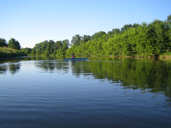
Expert and novice paddlers alike will enjoy the freedom of navigating the South Nation River. These waters meander though some of Ontario’s most productive agricultural and forested lands. Take in the local scenery and attractions along the River’s tranquil shores as you get to know the region by water.
South Nation Conservation’s canoe and kayak guide helps you safely plan for five separate, daylong trips. Please be aware that there is no camping along the South Nation River and arrangements for accommodations should be made ahead of time.
Beginning in the historic Village of Spencerville, these routes continue downstream through the most accessible and navigable parts of the river. Water conditions vary from placid sections to fast-moving stretches, making the South Nation ideal for family canoeing.
Times and distances in the guide vary according to: the skill sets of paddlers; time of year; and water levels. Always be aware of changing river conditions, and remember that there may be hazards that maps do not indicate. Learn more about up-to-date watershed conditions here or contact SNC for specific information when planning your outing.
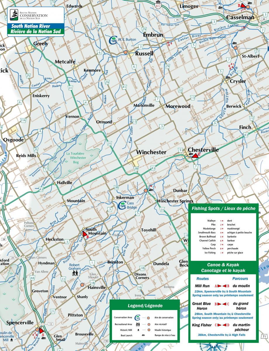
SNC offers a number of river access points and Conservation Areas providing various facilities located along the course of these routes.
 You will enjoy some of the most scenic views of the South Nation River when you paddle the Great Blue Heron Route, beginning in South Mountain. From County Road 3, turn onto Mill Street; this brings you to the water’s edge.
In some locations, you might see cattle accessing the water. If you encounter any, please stay clear and keep paddling.
Seasonally, there are fast-moving waters at the junction of the South and Main Branches of the River. SNC encourages you to portage along the top of the bank, until you pass the shallow, rocky area, and check water levels before continuing.
You will arrive at scenic Cass Bridge Conservation Area on the west side of the River. An open, green space; observation area; boat launch; play structure; picnic tables; parking; and privies are available at this site, south of the Village of Winchester.
The Chesterville boat launch and waterfront are on the west side of the River. You can access the boat launch by car on Queen Street, near the Main Street intersection. Park onsite and discover the restaurants and shops in this charming Village.
Under normal, early season conditions, there is a portage of about 0.5 km from the waterfront to the starting point of the King Fisher Route.
Starting point: Mill Street, South Mountain
Ending point: Queen Street, Chesterville
Estimated distance: 28 km (B-C on map)
Estimated time: 7.5 hours
Your on-water adventure starts below the Eric T. Casselman Dam in Chesterville. Access the Dam on William Street at St. Mary’s School and follow the path along the fence to the River’s edge.
Water levels can be low during the summer and towing your boat may be necessary for up to 4 km. The waters further downstream are easy to navigate and lead you to Crysler. Note: Beware of the orange and white buoys marking the approaching dam.
Take your canoe or kayak out of the water at the Crysler Village Park on the west side of the River, and portage about 0.5 km to the former site of St. John’s Anglican Church.
Access the River by portaging along Second Street; turning left onto Queen Street; crossing the bridge; and turning right on Charles Street. A gravel path leads down to the River where water levels are typically good year round from Crysler to Casselman. Make a stop at St-Albert Conservation Area, which offers privies and scenic, farmland views. Nearby, enjoy the St-Albert Co-Op Cheese Factory’s famously squeaky curds.
Downstream of St-Albert, you will reach High Falls Conservation Area in Casselman. Enjoy a picnic in the parkland on either side of the River’s edge while taking views of century-old dam ruins. Privies and garbage cans are available for your convenience. Orange and white buoys mark an approaching dam downstream, and you will need to remove your watercraft at the boat launch.
Starting point: William Street, Chesterville
Ending point: County Road 3, Casselman
Estimated distance: 38 km (C-D on map)
Estimated time: 9.5 hours
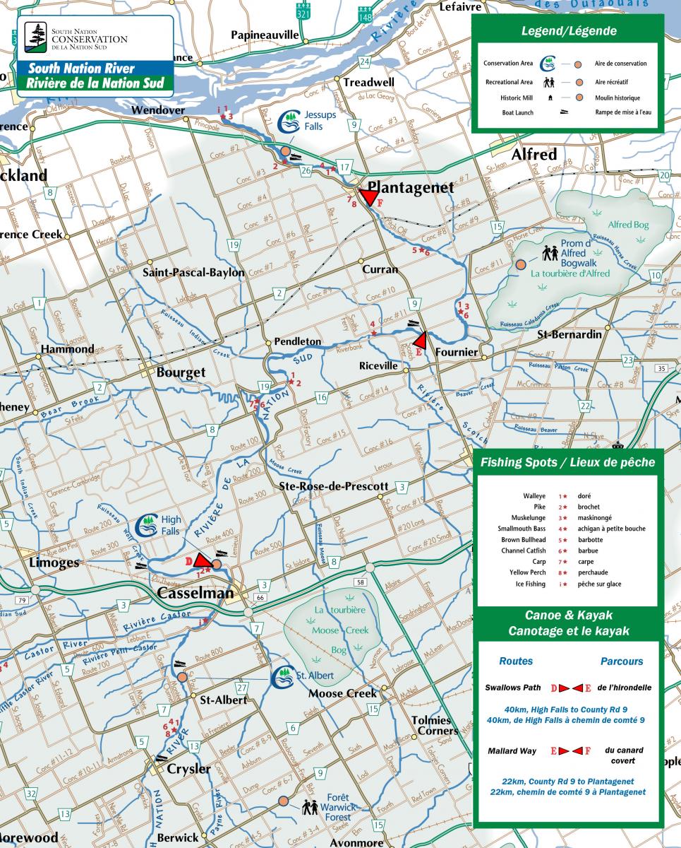
Begin your journey on the Mallard Way route at the Séguin Bridge River Access off County Road 9, north of St. Isidore. Launch your boat from the downstream side of the bridge and be aware that there is no other public access point to the River until the Village of Plantagenet. Paddle cautiously when approaching the railway bridge in Plantagenet Station—there is a small weir immediately downstream, which you will portage. Note: Exiting the steep riverbanks at this location can be challenging.
The stretch of the River between Plantagenet Station and the Village of Plantagenet is passable in the spring and early summer, but the rock outcropping known as the “pitch off,” may slow paddlers down. A survey of the natural features of the River from the pitch-off road should help you navigate your route. In the Village of Plantagenet, access the water at Plantagenet Village Park, off Plantagenet Road. Parking is available at this location.
Starting point: Seguin Bridge, County Road 9
Ending point: Plantagenet Road, Plantagenet
Estimated distance: 22 km (E-F on map)
Estimated time: 6 hours
Paddle the headwaters of the South Nation River upstream of a 200-year-old grist mill—the last one that operates on these banks. The popular Mill Run route has high water levels in the early spring, producing rapids and eddies for an exciting start to your journey.
Parking is available at the mill. You will have to tow your boat up Water Street on-foot, to the River Access beyond the bridge.
This pastoral trip along the countryside features mature hardwood stands and hemlock groves. Keep an eye out for waterfowl—there are excellent opportunities to catch site of osprey and great blue herons.
Starting point: Water Street, Spencerville
Ending point: South Mountain
Estimated distance: 22 km (A-B on map)
Estimated time: 6 hours
Access the Swallows Path route beyond High Falls Conservation Area in Casselman, from Rue Principle South to Rue Brisson. Follow this Road for about 300 m to the River Access.
Over twenty years ago, 17 hectares of farmland gave way into the South Nation River. As you paddle this course near the bridge in the former Hamlet of Lemieux, you will see evidence of this landslide, and another from 1971, upstream. The presence of leda clay, high steep banks, and wet ground conditions found in this part of the watershed, are major contributors to such natural disasters. The River is fairly narrow in some areas from Casselman to the Séguin Bridge because of landslide scars.
Watch for groups of holes near the top of steep riverbanks on your travels to the Séguin Bridge—this is habitat for bank swallows. These migratory songbirds build nests in vertical cliffs by digging 60-90 cm tunnels with their bills and feet.
Starting point: Rue Brisson, Casselman
Ending point: County Road 9, Fournier
Estimated distance: 40 km (D-E on map)
Estimated time: 10 hours